
Boundary Disputes Surveyors: When to Instruct One
The popular advice is simple: if a neighbour moves a fence, instruct a boundary surveyor immediately. That's often poor advice. Many disagreements involve a narrow strip of garden, unclear historic documents or a feature that both owners have assumed was correct for years. The sensible first move is to establish what has happened, then choose the least formal evidence that can resolve it.
That doesn't mean ignoring a serious encroachment. It means avoiding an expensive escalation before you know whether you need a measured plan, a surveyor's opinion, mediation or a solicitor's strategy. In London, where Victorian terraces, converted flats and small gardens put neighbours close together, proportionality matters.
Table of Contents
- Not Every Boundary Argument Needs a Surveyor
- Why Title Plans Do Not Show Your Exact Boundary
- What a Boundary Surveyor Investigates
- Routes to Resolving a Boundary Dispute
- How to Choose the Right Boundary Surveyor
- Boundary Disputes in Practice Across London
- Your Next Steps After Reading This Guide
Not Every Boundary Argument Needs a Surveyor
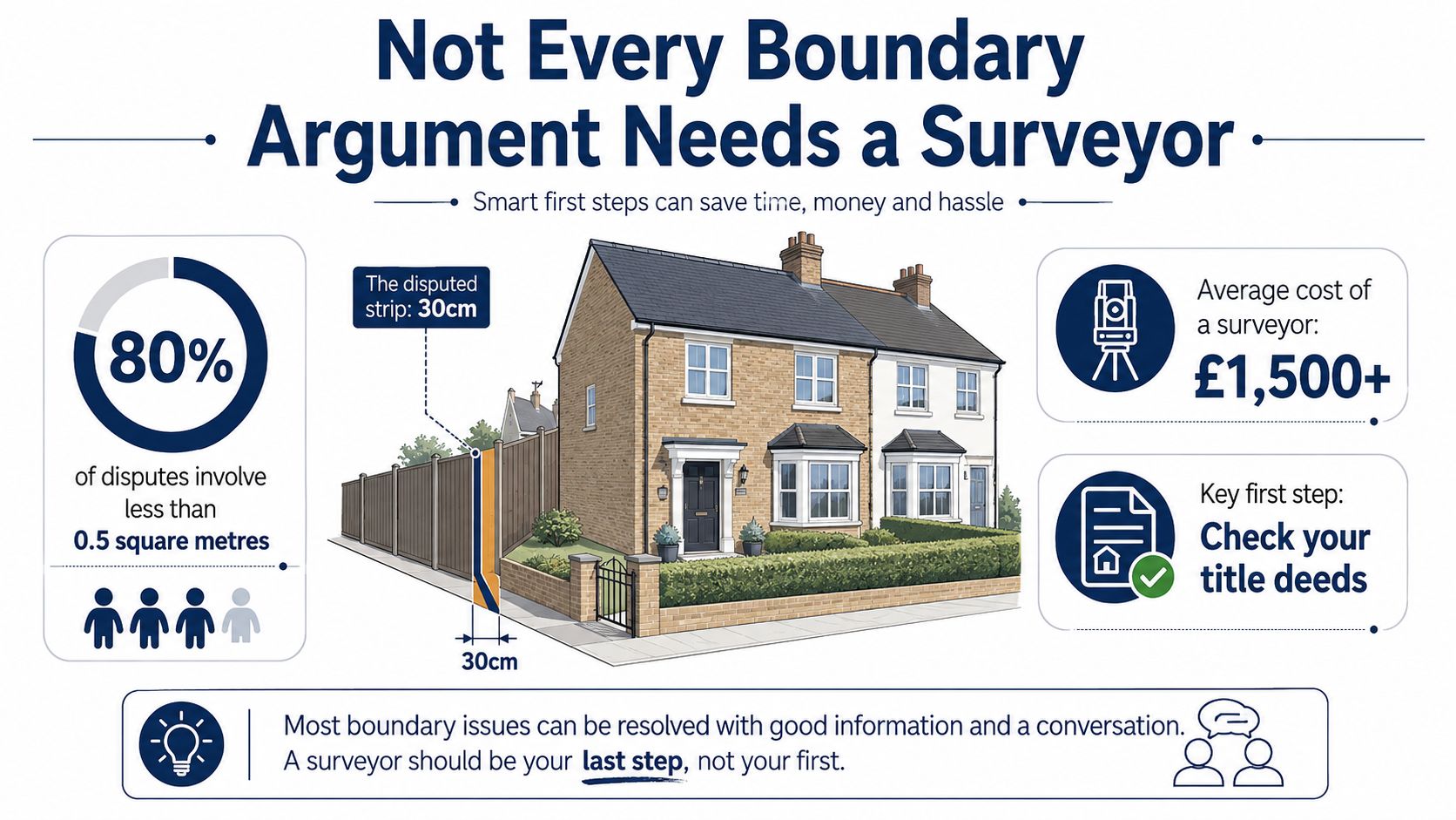
A neighbour's new fence can feel like an obvious trespass. It may not be. The fence could have replaced an older feature in the same position, the title plan might only show a general boundary or the disagreement might concern maintenance rather than ownership.
Start by separating an irritation from a dispute that needs evidence. If both owners can discuss the position calmly, check their deeds and agree to leave the feature where it is, professional involvement may add little. Put any agreement in writing and take care with the wording. An informal note is not necessarily the same as a formal boundary agreement.
The scale of the problem also matters. Direct Line's UK-wide snapshot found that nearly 11 million people, or 23% of UK homeowners, had been involved in a property boundary issue. It recorded 6.6 million homeowners, or 14%, reporting a boundary argument in the previous 12 months. The same research found that the land contested collectively amounted to about 150 million square feet, roughly six square miles or nearly 2,000 football pitches. Direct Line's boundary dispute snapshot shows how a seemingly small issue can become a substantial national burden.
Yet the same evidence points towards triage. The average area in dispute was about 2% of the average garden, according to RICS guidance on boundary disputes. That doesn't make the issue unimportant. It does mean that a full determination exercise may be excessive at the outset.
A practical first assessment
Before instructing anyone, gather:
- Your title documents: Find the register, title plan, transfer, conveyance and any plans referred to in them.
- Historic evidence: Look for older photographs, planning drawings, dated sale particulars and correspondence.
- The physical position: Record the fence, wall, hedge, posts, paving and building features without moving anything.
- The neighbour's position: Ask what they believe the boundary is and why. Keep the discussion factual.
A surveyor earns their fee when the parties need an impartial interpretation, a measured plan or evidence suitable for negotiation and legal proceedings. They can't decide ownership just by looking at a red line, and they can't force a neighbour to accept an opinion.
Practical rule: If the disagreement affects a sale, proposed building work, access, a valuable part of the garden or a threatened claim, obtain professional advice before changing the site.
Why Title Plans Do Not Show Your Exact Boundary
HM Land Registry title plans usually show a general boundary, not a precisely surveyed legal line. The red edging is a useful starting point, but it isn't a measurement of the fence line on the ground. HM Land Registry guidance on boundary plans explains that a title plan is only a general guide unless the boundary has been formally determined or recorded through a boundary agreement.
That distinction causes much of the confusion. A red line on a plan may be several millimetres wide when printed, yet represent a much larger area on the ground. The plan also may not have been prepared to show every wall, fence or change made since the title was created.
Read the documents in the right order
A boundary surveyor normally considers the title plan alongside the wording of the transfer or conveyance. The document may describe a boundary by reference to a feature, a dimension, a neighbour's land or an attached plan. Those clues need to be tested against the site.
Physical evidence can then support or challenge the documentary interpretation. A long-standing fence, a hedge base, old gateposts, building corners and changes in paving may all matter. None is automatically decisive. A fence can be misplaced, a hedge can grow over a line and a wall can have been rebuilt.
The RICS guidance on topographic surveys and boundary disputes makes the practical point clear: surveyors use deeds, site evidence and measured plans because the title plan alone doesn't fix the exact line on the ground.
For readers checking the wider financial implications of a property issue, this guide to checking a property's value in the UK may also be useful. A boundary problem can affect marketability even where the disputed strip has little standalone value.
Determined boundaries are different
A determined boundary is a formal process. It requires a precise plan and supporting evidence, rather than a household assumption about where the fence ought to sit. This is not the right starting point for every disagreement. It is a route to consider when the location needs formal recording and the parties cannot settle the issue through a proportionate agreement.
What a Boundary Surveyor Investigates
A boundary investigation follows a defined four-part process: a measured topographic survey, a document review, physical evidence analysis, and a written opinion. The scope should match the dispute. A London homeowner may need a focused advisory opinion, not a full determination exercise, if the evidence supports a practical settlement.
RICS says boundary disputes in England and Wales should first be handled by a chartered land surveyor specialising in boundary work, using the current edition of its boundary-identification guidance. The surveyor separates the legal question from the evidence found on site. Title plans and conveyances alone often cannot fix the exact line.
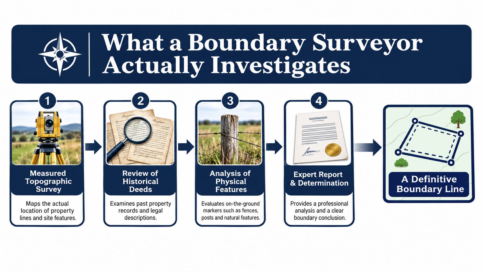
The investigation usually has four parts
Measured topographic survey: The surveyor records the relevant land and surrounding features, including buildings, walls, fences, hedges, trees, paths and fixed reference points. The level of accuracy should fit the circumstances, rather than produce a plan that only looks convincing.
Document review: The surveyor examines transfers, conveyances, filed plans, historic plans and relevant correspondence. Legal interpretation remains a matter for a solicitor or the court. The surveyor establishes how the documents relate to the physical site.
Physical evidence analysis: Measurements are compared with features on the ground. A gatepost may align with a historic plan. A hedge may have spread across the line. An extension may sit close to, or over, the disputed area. These features inform the opinion, but none decides the boundary alone.
Written opinion or expert report: The result may be an advisory opinion for negotiation or a full expert witness report for formal proceedings. These products serve different purposes. Confirm the scope before you agree the fee.
The technical standard matters. Land Registry guidance says a boundary plan should be accurate to plus or minus 10 millimetres horizontally, measured from at least two fixed points on permanent surrounding features, preferably from both sides of the boundary. Its guidance on determined boundaries also refers to coordinate accuracy of plus or minus 300 millimetres absolute and plus or minus 10 millimetres relative. A small surveying error can therefore alter the apparent position of a disputed line.
For clients who need to understand how technical plans are reproduced, this modern blueprint printing guide provides useful background.
The video below gives further visual context on the work involved.
A surveyor does not grant land to either owner. The report records the evidence and gives an opinion. The parties, their solicitors or the court decide what happens next.
Routes to Resolving a Boundary Dispute
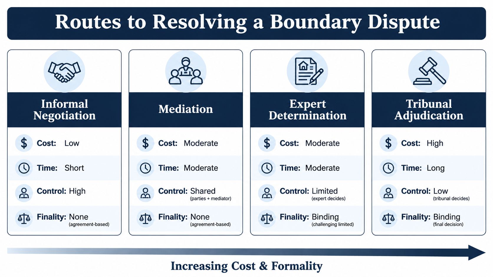
The right route depends on the strength of the evidence, the neighbour's attitude and the consequence of getting the issue wrong. Start with the least formal option that can realistically work. Escalate when cooperation fails or the risk justifies it.
Informal negotiation suits a disagreement where both owners are willing to share documents and discuss a practical outcome. A short letter setting out the issue, supported by photographs and a plan, may achieve more than an aggressive solicitor's letter. Don't move a fence or remove a hedge while the position remains disputed.
Mediation brings in an independent person to help the parties reach an agreement. The mediator doesn't decide the legal line. This route can work particularly well in Forest Hill, Lewisham, Dulwich and similar areas where neighbours will continue living alongside one another after the dispute ends.
Expert determination involves a suitably experienced surveyor or lawyer evaluating the evidence. The parties must agree the terms, including whether the decision will be binding. The judiciary's guidance on boundary disputes and expert determination identifies this as an alternative route where the parties agree to a binding evaluation.
Tribunal or court proceedings are formal and should not be the default response to a misplaced fence. A solicitor should advise on pleadings, evidence, limitation issues and the risks before proceedings begin.
The government-backed English scoping study recorded about 1,200 referrals each year to the Land Registration Division of the First-tier Tribunal, with around 500 cases formally adjudicated or otherwise disposed of. Not all referrals were boundary cases. The study estimated that boundary disputes may have made up roughly one-third of the total, suggesting about 160 to 170 boundary disputes annually before that tribunal. It also recorded surveyors' estimates of three to four boundary disputes per day, or more than 1,000 per year. The government boundary disputes scoping study supports a practical conclusion: many disputes are investigated by surveyors without reaching formal adjudication.
Don't confuse a boundary issue with a party wall issue
A boundary dispute concerns the position or ownership of land. Party wall procedures concern particular building work and shared structures under the Party Wall etc. Act 1996.
In England and Wales, written notice is required before relevant work starts. The notice period is one month for certain new boundary wall or excavation works and two months for work to an existing party wall or structure. If the neighbour doesn't agree within 14 days, a dispute arises and surveyors must be appointed to resolve it through an Award. RICS party wall guidance explains the distinction.
If building work is involved, read this advice on party wall surveyors in London before treating the matter as a simple fence-line argument.
How to Choose the Right Boundary Surveyor
Don't assume every chartered surveyor specialises in boundary disputes. Boundary work requires a particular approach to deeds, historic evidence, measured plans and expert reporting.
Look for a RICS Chartered Surveyor who regularly handles boundary identification and dispute resolution. CABE qualifications are also relevant to built-environment expertise, particularly where the dispute involves extensions, walls, alterations or construction defects. Ask the surveyor which current RICS boundary guidance they follow.
Questions to ask before instructing
- Relevant experience: Have you dealt with boundary disputes involving Victorian terraces, converted flats or suburban semis in my borough?
- Scope of work: Will you review the deeds, inspect the site, prepare a measured plan and provide an advisory opinion?
- Report type: Is the report for private negotiation, mediation, expert determination or possible court proceedings?
- Independence: Do you have ties to a lender, estate agent, developer or contractor connected with the property?
- Insurance and complaints: Do you carry professional indemnity insurance, and what is your complaints process?
Independence matters. Corinthian Surveyors London LTD is an independent practice with no ties to lenders, estate agents or developers. It is RICS regulated, has a RICS and CABE qualified principal, is a member of the RICS Valuers Registration Scheme and is insured by Royal Sun Alliance. The firm operates from Forest Hill and serves all London boroughs, the Home Counties and the South of England.
That doesn't mean you must use Corinthian. It means you should compare like with like. The guide to residential land surveyors will help you understand the questions that separate a genuine land specialist from a surveyor who mainly undertakes mortgage-related inspections.
You should also ask for a written scope before work begins. A proportionate advisory opinion may be enough at the first stage. If litigation is already threatened, the surveyor needs to know that before preparing the report, because expert evidence must meet the requirements of the process in which it will be used.
Boundary Disputes in Practice Across London
A Victorian terrace in Lewisham presents a familiar problem. One owner builds an extension beside the party wall and the neighbour believes the works have crossed the boundary. The first task is not to accuse anyone of trespass. It is to compare the transfer, historic plans, the building footprint and the measured position of the wall. The outcome may be a boundary opinion, a party wall matter or a construction issue, and each needs different advice.
In Bermondsey, a converted warehouse flat can create a different difficulty. The flat owner may believe a balcony, roof terrace or access route belongs exclusively to them, while the lease and registered plan describe rights and limits less clearly. A surveyor can measure the physical arrangement and identify inconsistencies. A solicitor may then need to interpret the lease and advise on rights of access or alterations.
A 1930s semi in Bromley often brings a long-established hedge into the argument. The hedge may have shifted, widened or been replanted over the years. The current line looks obvious, but the relevant evidence may lie in an older conveyance, a historic fence position or fixed features at the front and rear of the plot.
The sensible outcome is often narrower than expected
London's dense housing stock makes small discrepancies feel personal. A strip beside a kitchen extension can affect light, access, maintenance and future sale discussions even when its area is modest.
The right report may settle the issue without litigation. It might confirm that the existing fence is defensible, identify a need for a negotiated adjustment or show that the parties need legal advice before taking action. A surveyor should explain the limits of the evidence rather than promise a result.
For Corinthian Surveyors London LTD, boundary work sits alongside party wall advice, defect analysis and expert witness inspection. Clive Thompson works across South East London, including Lewisham, Greenwich, Bromley, Croydon, Lambeth and Southwark, where the age and density of residential property often make site evidence as important as the paperwork.
Your Next Steps After Reading This Guide
Begin with the documents. Obtain the register, title plan, transfer or conveyance and any historic plans. Photograph the site without moving the fence, hedge, wall or other feature.
Then decide what you need:
- A discussion and written agreement if the issue is minor and both owners are cooperative.
- A measured site plan or advisory opinion if the physical position is unclear.
- A full expert report if determination, mediation or court proceedings are being considered.
- A solicitor's advice if ownership, adverse possession, an injunction or formal proceedings are involved.
- Party wall advice if proposed excavation, a new boundary wall or work to a shared structure is part of the problem.
Brief the surveyor clearly. Explain the history, provide every document and say whether the report is for negotiation or formal use. That prevents you paying for the wrong level of investigation.
For independent boundary advice in London and the Home Counties, Corinthian Surveyors London LTD provides RICS-regulated residential surveying, measured investigation and expert witness inspection. You can discuss the issue with the Forest Hill office on 0800 00 16 422 before deciding whether a surveyor is justified.
Corinthian Surveyors London LTD can review your boundary documents, inspect the site and advise whether you need a measured plan, an advisory opinion or expert evidence. Visit Corinthian Surveyors London LTD to outline the property and the dispute before taking the next step.